Wednesday, July 31, 2013

Hoquiam River RV Park, Hoquiam, WAAfter doing a grocery run we headed north up the coast.  Yesterday we drove inland to Quinault Lake and environs.  Today we stuck to the coastal road.  This was a much prettier drive than we expected.  One beach resort after another all the way up the coast.  The most impressive of these was Ocean Shores.  This rather large community was well laid out—with a four-lane road separated by a large grassy area.  So traffic ran smoothly.  And there was every conceivable restaurant, a hardware store, several grocery stores, a mall, a cinema, a convention center and a huge casino.  You could rent mopeds, four-runners, kayaks, and even horses. Deer were roaming around everywhere.  We drove onto the beach and headed north on the beach for a while.  I’m not a proponent of driving on the beach, but it wasn’t too bad.  The beach was broad and beautiful, but what good is it?  You can’t swim in the ocean, or even lay on the beach.  The temperature was a scant 60.  But of course some do.  Had a late lunch farther up the coast at Mill 109 in Seabrooke, WA. On the way home we stopped at a fruit stand and picked up some more Rainier cherries and some blackberries. Back to our RV park and relaxed the rest of the evening.  I finished a great book, “The Great Train Robbery” by Michael Chrichton.  A great story of a huge train robbery pulled off with great aplomb by a cheeky and ballsy fellow in Victorian England.  And a true story!  Would make a great movie.  Just started “Bridges of Madison County”.  64 today and mostly cloudy. Well, we are in a rain forest after all.

Washington beach near Queets.
Mill 109--great place for lunch.

Tuesday, July 30, 2013

Hoquiam River RV Park, Hoquiam, WAHeaded north today to Olympic National Forest and Quinault Lake.  Hiked a trail to a huge, old cedar.  Actually, it was dead.  But it was huge.  And totally hollow on the inside.  A family of six could live in there.  A pretty strenuous hike up steep terrain.  Fortunately, I went back and got my trekking poles.  Hiked another rain forest trail which was a lot easier.  We started out in a lot of clouds and mist.  But by the time we got to Quinault Lake it had cleared.  Stopped at the beautiful Quinault Lake Lodge for a late lunch or early dinner, but, alas, we were too late for lunch and too early for dinner.  So we checked out the menu at the bar and got a couple of sandwiches and drinks and ate on their deck overlooking this beautiful lake.  After a relaxing lunch we drove further up the lake road and noticed another restaurant.  Stopped there and had a couple of drinks and then drove back to Hoquiam.  64 today.


Huge cedar tree.


Inside huge cedar tree, looking up.


Quinault Lodge

Fireplace at the Quinault Lodge


View of Quinault Lake from the grounds of the lodge.


Monday, July 29, 2013

Hoquiam River RV Park, Hoquiam, WAHeaded out late morning to explore around a little.  Drove south to Westport which is a cute little fishing village.  Then continued on down the coastal road.  But not much to see.  Apparently, all the beauty of Washington lies inland, not on the coast.  Cloudy all morning, but cleared off by 2:30.  Still only 65.

Grays Harbor Lighthouse

Sunday, July 28, 2013

Tower Rock NF Campground, Randle, WA, to Hoquiam River RV Park, Hoquiam, WA:  Spent the last 9 days in beautiful Gifford Pinchot National Forest.  Our campground was small--22 sites--and very pretty.  Lots of large Douglas firs in here--one which rivals the giant redwoods in California.  We were here to explore Mt. St. Helens, Mt. Rainier, and environs.


Mt. St. Helens:  This was a very interesting learning experience for us.  Mt. St. Helens was what they call a dry eruption.  No lava, but tons of rock, dirt, and extremely hot gasses.  And it was a side blast.  The north side of the mountain started developing a bulge which grew at the rate of an average 5 feet per day.  It had bulged out 400 feet just before it blew.  The geologists expected an upward, lava event.  So they declared an evacuation zone of 5 miles.  This thing blew 17 miles laterally, snapping huge, old growth trees and depositing up to 600 feet of ash and rocks in the Toutle River valley.  Spirit Lake sits at the foot of the mountain and as a result of the blast it now sits 200 feet higher because of all the stuff that sits at the bottom of the lake--mainly trees.  It's bigger now because it was "bumped up" 200 feet, but shallower.  A man by the name of Harry Truman owned at lodge on the lake but refused to leave.  He and the lodge are now under 200 feet of ash, rock, and other debris.  57 people lost their lives.  And there are many stories of people in the blast zone who miraculously survived.


This is a picture of a picture and not very clear, but this is Mt. St. Helens before the blast.

This is a picture taken after the blast.  The surrounding mountains in the blast zone which were covered in a lush conifer forest were blasted down to bare rock.

Spirit Lake with lots of floating logs.  
And we noticed when we were up there a second time, a new bulge is forming in the crater.  And steam was coming out.  Yikes!


Mt. Rainier:  This place was magical.  Mountains covered in firs as far as the eye can see, beautiful waterfalls crashing down lofty mountains, pristine streams, wild flowers in abundance, alpine meadows—and in the center of it all, beautiful and majestic, glacier-topped Mt. Rainier.  We stopped at every viewing spot possible and eventually made it up to Paradise Inn, the lodge in the shadow of Mt. Rainier.  We had planned to eat there, but the restaurant didn’t open for dinner until 5:30.  There is a paved pathway leading up the mountain from the Visitor Center and Paradise Inn that goes through alpine meadows of great beauty.   Since we’re starting to feel the effects of the altitude, we didn’t even attempt this.


Beautiful wildflowers!

Paradise Lodge and Inn.
In the center of it all--beautiful Mt. Rainier.

We went back to Mt. Rainier a couple of days later and hiked the Grove of the Patriarchs Trail.

These two are over 1000 years old!  The trees, that is.
We drove in to Randle from our campground several times to have breakfast or dinner at our favorite restaurant, Tall Timbers.  One morning we ran into these two--Danna and her beautiful husky/wolf mix dog, Arou.  

Danna and her dog, Arou.


Arou--husky/wolf mix.

Thursday, July 18, 2013

Ft. Stevens State Park, near Astoria, OR:  Left this morning early—for us anyway—and headed south on the 101 to see the Oregon coast that we missed when we headed inland to Portland a couple of weeks ago.  Started out under cloudy skies, but it cleared pretty quickly to reveal a pretty blue sky.  Stopped at what is now Ecola Beach where Capt. Lewis and some of his party (including Sacajawea) traveled down the beach from Ft. Clatsop to obtain some whale blubber from a dead whale that washed up on shore.  When they got there, only a skeleton was left, but they bought 300 lbs. of blubber and some whale oil from the Indians.  This would be a welcome addition to their meager diet of mostly elk and fish.  We also stopped in the cute little town of Seaside to see the salt works that members of the Lewis and Clark party built and used to make salt.  Had lunch at a little place on the bayocean peninsula where a river (don’t remember which one) meets the Pacific.  Came back and stopped at Ft. Stevens which was used from the Civil War through WWII.  It was decommissioned in 1947 and ceded to the state and became Ft. Stevens SP.  Back to our site and relaxed.  Our last day in Oregon.  Tomorrow we leave for a National Forest campground between Mr. Rainier and Mt. St. Helens in Washington.  If all goes well, we’ll be there for 9 days.  No hook-ups.  67 today.

Surfers out there doing their thing.  Air temperature was 61.  Water temps probably in the 50s.  Brrrrr!

I read somewhere that these huge rocks are what used to be headlands.

Tillamook Rock Lighthouse.  This is located 1.2 miles off Tillamook Head south of Seaside.  It has a 62-foot high tower and stands 135 feet above sea level on a basalt rock islet.  Its exposure to fierce storm waves gave rise to its nickname, "Terrible Tilly".  We've now seen every lighthouse on the Oregon coast.

This stretch of the 101 which rises high above the Pacific has the most extensive rock work of the whole highway.  It's basically holding up the road.  
Salt works--just off the beach in what is now Seaside.  Some members of the Lewis & Clark party camped here from January 2, 1806, to February 17, 1806, and made salt.
Me and Sacajawea
Picture by Mike

Wednesday, July 17, 2013

Ft. Stevens State Park, near Astoria, ORCloudy and cool all day today.  We went to the Maritime Museum in Astoria which is a fairly new museum in this small river town.  We could also tour a light ship, the Columbia.  There are some really large ships that ply the Columbia River.  Where the river meets the ocean is pretty dangerous, and waves of 40 feet are common.  Ships are required to stop 6 miles out and take on a “bar pilot” which takes them up the mouth of the Columbia River to the bridge in Astoria.  Then they need a river pilot to take them up to Portland, or wherever. No wonder Lewis and Clark couldn’t make it out to the Pacific from the Columbia River in their canoes.  The waves were so high they kept getting swamped.  We had lunch at a little diner in Astoria and then headed back to our park.  Took a drive down to the beach to view the wreck of the Peter Iredale, which ran aground in 1906 on Clatsop Spit which is now part of the park.  The wrecked hull of the ship sits on the beach, and has for ~70 years.  68 today.


This is a map of all the ship wrecks in and around the mouth of the Columbia River.

Large ships ply the Columbia.  This one is from Hong Kong.  They anchor in the Columbia and wait for word that they can continue on to Portland.  There's no charge to anchor here, whereas in Portland they could be charged up to $1000/day for dockage.


This Japanese boat washed up on Cape Disappointment on the Washington side of the Columbia--a result of the tsunami.


Coast Guard rescue boat on the crest of a huge wave.  This boat is auto bailing and would automatically right itself in the event it capsized.  


The wreck of the Peter Iredale on an Oregon beach.


Tuesday, July 16, 2013

Ft. Stevens State Park, near Astoria, ORWell, it was supposed to be 80 and sunny today.  And it was sunny early this morning. But by the time we got dressed and headed out, the clouds had moved in.  Drove back to Astoria because I wanted to check out a possible river cruise.  Then we headed back to Ft. Clatsop, stopping in Warrenton for some lunch.  Ft. Clatsop is where Lewis & Clark and the Corps of Discovery wintered before heading back to St. Louis.  And we visited here on an appropriate day, since of the four months they spent here, only 13 days were without rain.  Still cloudy and now sprinkling off and on.  Although they were busy putting up provisions for their return trip (they made 385 pairs of moccasins for the men) boredom still set in.  And they were pretty miserable with the constant rain and cold.  After leaving there we searched out and found the place where a Japanese submarine shelled the Oregon coast.  The only time the mainland was shelled during WWII.  It didn’t do any damage or anything, but I’m sure it got everyone’s attention.  Only 65 today, cloudy and damp.

Ft. Clatsop front entrance.

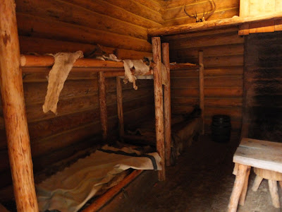
Cabins where the Corps lived.

Fort's back entrance which led to the spring.

Captain's quarters.

I never knew about this shelling of the Oregon coast by a Japanese submarine.

Sculpture of Sacajawea and her son, Jean Baptiste.  She's 16 years old.